
CRETE TRAVEL GUIDE
Αξιοθέατα
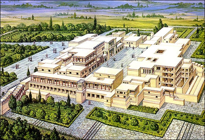
The principal centre of the Minoan Civilisation.
Knossos is the site of the most important and better known palace of Minoan civilisation. According to tradition, it was the seat of the legendary king Minos. The Palace is also connected with thrilling legends, such as the myth of the Labyrinth with the Minotaur, and the story of Daidalos and Icaros.
Minoan civilisation
The site was continuously inhabited from the Neolithic period (7000-3000 B.C.) until Roman times. The Linear B tablets (Mycenaean script) of the 14th century B.C. mention the city as ko-no-so.
Intensive habitation occured mostly in the Minoan period, when the so-called first (19th-17th centuries B.C.) and second palaces (16th-14th centuries B.C.) were built along with luxurious houses, a hospice and various other structures. After its partial destruction in 1450 B.C., Knossos was settled by Mycenaeans from the Greek Mainland.
The city flourished again during the Hellenistic period (sanctuaries of Glaukos, Demeter, other sanctuaries, chamber tombs, north cemetery, defensive towers) and in 67 B.C. it was captured by the Roman Quintus Caecilius Metelus Creticus. The "Villa of Dionysos", a private house with splendid mosaics was built in the same period.
Εxcavations & restoration
Knossos was discovered in 1878 by Minos Kalokairinos. Sir Arthur Evans conducted systematic excavations at the site between 1900 and 1931, bringing to light the palace, a large section of the Minoan city, and the cemeteries. Since then, the site and the surrounding area have been excavated by the British School of Archaeology at Athens and the 23rd E.P.C.A.
The restoration of the palace to its present form was carried out by Arthur Evans. The interventions were mostly imposed by the need to preserve the monuments uncovered. The Archaeological Service of the Ministry of Culture carries out only consolidation work, whenever necessary.
Ticket:
Full: €15, Reduced: €8
In order to purchase tickets online for the archeological site of Knossos visit the official e-ticketing service of the Hellenic Ministry of Culture and Sports at www.etickets.tap.gr
Summer:
Opening hours from the 18th of May 2020 are as
follows:
08:00 – 20:00 every day (last admission 19:45)
407 místní doporučují
Knossos
The principal centre of the Minoan Civilisation.
Knossos is the site of the most important and better known palace of Minoan civilisation. According to tradition, it was the seat of the legendary king Minos. The Palace is also connected with thrilling legends, such as the myth of the Labyrinth with the Minotaur, and the story of Daidalos and Icaros.
Minoan civilisation
The site was continuously inhabited from the Neolithic period (7000-3000 B.C.) until Roman times. The Linear B tablets (Mycenaean script) of the 14th century B.C. mention the city as ko-no-so.
Intensive habitation occured mostly in the Minoan period, when the so-called first (19th-17th centuries B.C.) and second palaces (16th-14th centuries B.C.) were built along with luxurious houses, a hospice and various other structures. After its partial destruction in 1450 B.C., Knossos was settled by Mycenaeans from the Greek Mainland.
The city flourished again during the Hellenistic period (sanctuaries of Glaukos, Demeter, other sanctuaries, chamber tombs, north cemetery, defensive towers) and in 67 B.C. it was captured by the Roman Quintus Caecilius Metelus Creticus. The "Villa of Dionysos", a private house with splendid mosaics was built in the same period.
Εxcavations & restoration
Knossos was discovered in 1878 by Minos Kalokairinos. Sir Arthur Evans conducted systematic excavations at the site between 1900 and 1931, bringing to light the palace, a large section of the Minoan city, and the cemeteries. Since then, the site and the surrounding area have been excavated by the British School of Archaeology at Athens and the 23rd E.P.C.A.
The restoration of the palace to its present form was carried out by Arthur Evans. The interventions were mostly imposed by the need to preserve the monuments uncovered. The Archaeological Service of the Ministry of Culture carries out only consolidation work, whenever necessary.
Ticket:
Full: €15, Reduced: €8
In order to purchase tickets online for the archeological site of Knossos visit the official e-ticketing service of the Hellenic Ministry of Culture and Sports at www.etickets.tap.gr
Summer:
Opening hours from the 18th of May 2020 are as
follows:
08:00 – 20:00 every day (last admission 19:45)
Natural History Museum
Operating within the wider University of Crete framework, the Natural History Museum of Crete fulfils all the roles demanded of a comprehensive, modern museum by:
Keeping and developing collections
Carrying out research into the natural world
Contributing to teaching at all levels in the education system
Promoting the unique nature of habitats in Crete and the Mediterranean.
The museum''s impressive growth over the last decade reflects the competence and professionalism of its staff, as well as the growing need in society for proper information concerning the environment.
Contact details:
Natural History Museum Exhibition
Sof. Venizelou Ave, Dermatas Bay
Tel. (+30)2810 / 282740
e-mail: sec@nhmc.uoc.gr
Website: http://www.nhmc.uoc.gr
Admissions
General Admission Fee: 7.5 €
Reduced Admission Fee: 4.5 €
Opening hours
Monday to Friday 09:00 - 15:00
Weekends 10:00 - 18:00
227 místní doporučují
Přírodovědné muzeum Kréty
Leoforos Sofokli VenizelouNatural History Museum
Operating within the wider University of Crete framework, the Natural History Museum of Crete fulfils all the roles demanded of a comprehensive, modern museum by:
Keeping and developing collections
Carrying out research into the natural world
Contributing to teaching at all levels in the education system
Promoting the unique nature of habitats in Crete and the Mediterranean.
The museum''s impressive growth over the last decade reflects the competence and professionalism of its staff, as well as the growing need in society for proper information concerning the environment.
Contact details:
Natural History Museum Exhibition
Sof. Venizelou Ave, Dermatas Bay
Tel. (+30)2810 / 282740
e-mail: sec@nhmc.uoc.gr
Website: http://www.nhmc.uoc.gr
Admissions
General Admission Fee: 7.5 €
Reduced Admission Fee: 4.5 €
Opening hours
Monday to Friday 09:00 - 15:00
Weekends 10:00 - 18:00
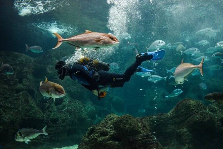
Opening Times of CretAquarium
CretAquarium remains open 365 days a year 7 days a week, even during festive periods and holidays.
Winter Opening Times
( 1st November - 31st March) daily, 9.30 in the morning till 4 in the afternoon
Summer Opening Times
(1st April - 31st October) daily, 9.30 in the morning till 19:00 in the afternoon
Fees at CretAquarium
Entrance Fee
General Entrance Fee10€ (1/4 - 31/10)
Children 0-4 years oldFree Entrance
Children 5-17 years old6€
Seniors - Adults over 65 years old 6€
For the winter Season (01/11-31/03) the ticket price is reduced to 6€ for all categories.
A short tour around CretAquarium
The magic of the sea floor and the diving experience into such a familiar yet unknown world -the sea world of the Mediterranean - cannot be described in just a few words.
445 místní doporučují
Cretaquarium - Thalassocosmos
Opening Times of CretAquarium
CretAquarium remains open 365 days a year 7 days a week, even during festive periods and holidays.
Winter Opening Times
( 1st November - 31st March) daily, 9.30 in the morning till 4 in the afternoon
Summer Opening Times
(1st April - 31st October) daily, 9.30 in the morning till 19:00 in the afternoon
Fees at CretAquarium
Entrance Fee
General Entrance Fee10€ (1/4 - 31/10)
Children 0-4 years oldFree Entrance
Children 5-17 years old6€
Seniors - Adults over 65 years old 6€
For the winter Season (01/11-31/03) the ticket price is reduced to 6€ for all categories.
A short tour around CretAquarium
The magic of the sea floor and the diving experience into such a familiar yet unknown world -the sea world of the Mediterranean - cannot be described in just a few words.
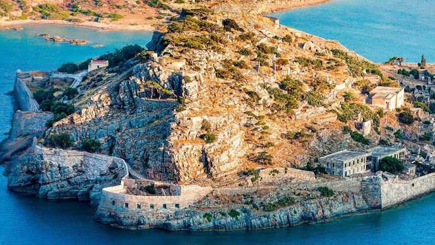
Spinalonga (Greek: Σπιναλόγκα) is an island located in the Gulf of Elounda in north-eastern Crete, in Lasithi, next to the town of Plaka. The island is further assigned to the area of Kalydon. It is near the Spinalonga peninsula ("large Spinalonga") – which often causes confusion as the same name is used for both. The official Greek name of the island today is Kalydon.
During Venetian rule, salt was harvested from salt pans around the island. The island has also been used as a leper colony. Spinalonga has appeared in novels, television series, and a short film.
Getting there
Ayios Nikolaos is only an hour’s drive away from Queen Aikaterini apartments, along the north road axis of the island.
Take the boat from Ayios Nikolaos, Elounda or Plaka. As well as the trip to Spinalonga you can also enjoy a swim off the beaches behind the Kolokytha Peninsula, before returning to Ayios Nikolaos in the afternoon
Price:
Boat from Plaka: 8 euros per person
Entrance ticket for Spinalonga: 8 euros per person
129 místní doporučují
Spinalonga
Spinalonga (Greek: Σπιναλόγκα) is an island located in the Gulf of Elounda in north-eastern Crete, in Lasithi, next to the town of Plaka. The island is further assigned to the area of Kalydon. It is near the Spinalonga peninsula ("large Spinalonga") – which often causes confusion as the same name is used for both. The official Greek name of the island today is Kalydon.
During Venetian rule, salt was harvested from salt pans around the island. The island has also been used as a leper colony. Spinalonga has appeared in novels, television series, and a short film.
Getting there
Ayios Nikolaos is only an hour’s drive away from Queen Aikaterini apartments, along the north road axis of the island.
Take the boat from Ayios Nikolaos, Elounda or Plaka. As well as the trip to Spinalonga you can also enjoy a swim off the beaches behind the Kolokytha Peninsula, before returning to Ayios Nikolaos in the afternoon
Price:
Boat from Plaka: 8 euros per person
Entrance ticket for Spinalonga: 8 euros per person
Area of natural beauty
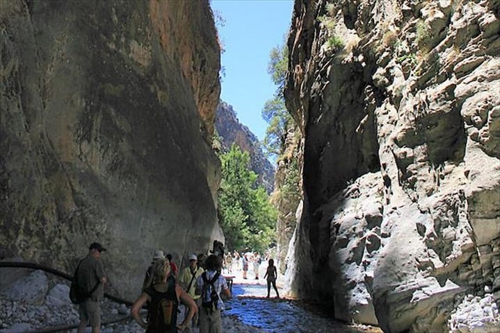
The Samariá Gorge (Greek: Φαράγγι Σαμαριάς or just Φάραγγας) is a National Park of Greece since 1962 on the island of Crete – a major tourist attraction of the island – and a World's Biosphere Reserve.
The gorge is in southwest Crete in the regional unit of Chania. It was created by a small river running between the White Mountains (Lefká Óri) and Mt. Volakias. There are a number of other gorges in the White Mountains. While some say that the gorge is 18 km long, this distance refers to the distance between the settlement of Omalos on the northern side of the plateau and the village of Agia Roumeli. In fact, the gorge is 16 km long, starting at an altitude of 1,250 m at the northern entrance, and ending at the shores of the Libyan Sea in Agia Roumeli. The walk through Samaria National Park is 13 km long, but one has to walk another two kilometers to Agia Roumeli from the park exit, making the hike 15 km long. The most famous part of the gorge is the stretch known as the Gates (or, albeit incorrectly, as "Iron Gates"), where the sides of the gorge close in to a width of only four meters and soar up to a height of almost 300 meters (980 feet). The gorge became a national park in 1962, particularly as a refuge for the rare kri-kri (Cretan goat), which is largely restricted to the park and an island just off the shore of Agia Marina. There are several other endemic species in the gorge and surrounding area, as well as many other species of flowers and birds.
The village of Samariá lies just inside the gorge. It was finally abandoned by the last remaining inhabitants in 1962 to make way for the park. The village and the gorge take their names from the village's ancient church, Óssia María.
A must for visitors to Crete is to complete the walk down the gorge from the Omalos plateau to Agia Roumeli on the Libyan Sea, at which point tourists sail to the nearby village of Sougia or Hora Sfakion, where they could spend a night there, or they could catch a coach back to Chania. The walk takes five to seven hours and can be strenuous, especially at the peak of summer.
Local tourist operators provide organized tours to the Gorge. These include bus transportation from one's hotel to the entrance (near Omalos village), and a bus connection that will be waiting for hikers after they disembark the ferry in Sougia or Sfakia (Chora Sfakion). If you are on your own, you can make a one-day round trip from Chania (see below) or from Sougia or Paleochora. Note that the morning buses from Sougia and Paleochora do not operate on Sunday. The ferries leave Agia Roumeli to Chora Sfakion (eastbound) and to Sougia/Paleochora (westbound) at 17:00.
Entrance fee
To enter the Gorge of Samaria there is an entrance fee that costs five (5) euros. Children under 15 years old have a free pass. The entrance fee is the same regardless you wish to enter the Gorge only for a few kilometers or for the entire route.
Note: It is important to keep your ticket in order to be checked at the exit. This is done for the safety of the visitors, since the Park rangers will know how many people have entered and exited the Gorge.
517 místní doporučují
Samaria Gorge
The Samariá Gorge (Greek: Φαράγγι Σαμαριάς or just Φάραγγας) is a National Park of Greece since 1962 on the island of Crete – a major tourist attraction of the island – and a World's Biosphere Reserve.
The gorge is in southwest Crete in the regional unit of Chania. It was created by a small river running between the White Mountains (Lefká Óri) and Mt. Volakias. There are a number of other gorges in the White Mountains. While some say that the gorge is 18 km long, this distance refers to the distance between the settlement of Omalos on the northern side of the plateau and the village of Agia Roumeli. In fact, the gorge is 16 km long, starting at an altitude of 1,250 m at the northern entrance, and ending at the shores of the Libyan Sea in Agia Roumeli. The walk through Samaria National Park is 13 km long, but one has to walk another two kilometers to Agia Roumeli from the park exit, making the hike 15 km long. The most famous part of the gorge is the stretch known as the Gates (or, albeit incorrectly, as "Iron Gates"), where the sides of the gorge close in to a width of only four meters and soar up to a height of almost 300 meters (980 feet). The gorge became a national park in 1962, particularly as a refuge for the rare kri-kri (Cretan goat), which is largely restricted to the park and an island just off the shore of Agia Marina. There are several other endemic species in the gorge and surrounding area, as well as many other species of flowers and birds.
The village of Samariá lies just inside the gorge. It was finally abandoned by the last remaining inhabitants in 1962 to make way for the park. The village and the gorge take their names from the village's ancient church, Óssia María.
A must for visitors to Crete is to complete the walk down the gorge from the Omalos plateau to Agia Roumeli on the Libyan Sea, at which point tourists sail to the nearby village of Sougia or Hora Sfakion, where they could spend a night there, or they could catch a coach back to Chania. The walk takes five to seven hours and can be strenuous, especially at the peak of summer.
Local tourist operators provide organized tours to the Gorge. These include bus transportation from one's hotel to the entrance (near Omalos village), and a bus connection that will be waiting for hikers after they disembark the ferry in Sougia or Sfakia (Chora Sfakion). If you are on your own, you can make a one-day round trip from Chania (see below) or from Sougia or Paleochora. Note that the morning buses from Sougia and Paleochora do not operate on Sunday. The ferries leave Agia Roumeli to Chora Sfakion (eastbound) and to Sougia/Paleochora (westbound) at 17:00.
Entrance fee
To enter the Gorge of Samaria there is an entrance fee that costs five (5) euros. Children under 15 years old have a free pass. The entrance fee is the same regardless you wish to enter the Gorge only for a few kilometers or for the entire route.
Note: It is important to keep your ticket in order to be checked at the exit. This is done for the safety of the visitors, since the Park rangers will know how many people have entered and exited the Gorge.
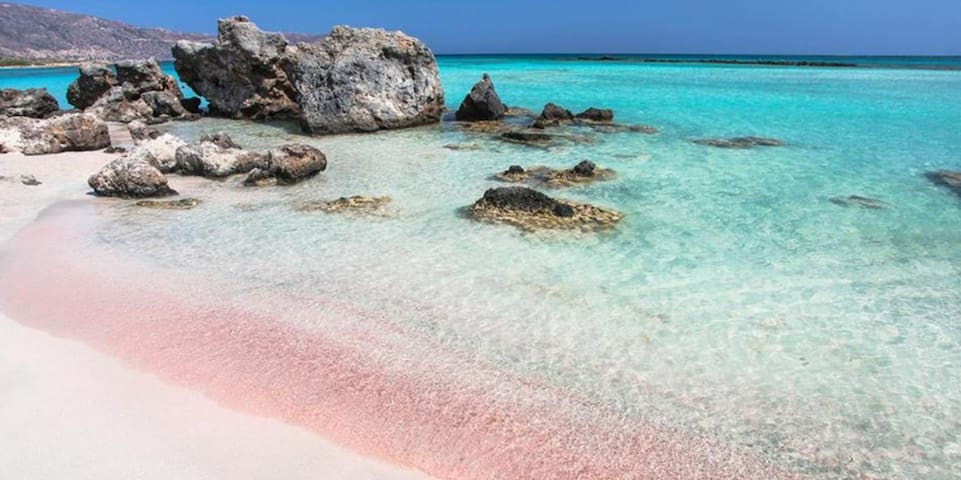
Elafonisi is located 192km west of Queen Aikaterini apartments, 76km west of Chania and 5km south of Chrysoskalitisa Monastery, in the southwesternmost tip of Crete. Elafonisi is an oblong peninsula, which often breaks in two parts by water giving the impression of being a separate island. It is a Natura 2000 protected area. The island is full of sand dunes with sea daffodils and jupiners. The endangered loggerhead sea turtle and several more rare animals and plants find shelter on the island; it is strictly forbidden to remove any plants, animals, shells and sand from the area.
Exotic beaches with white sand and turquoise water, reminding of the Caribbean, are formed on either sides of the peninsula. The sand is pinkish in many places, taking its color from millions of crushed shells. Near the breaking point of the peninsula, the sea water does not exceed 1m in depth, creating a small lagoon, ideal for children. You can easily cross the lagoon in order to reach the opposite site of the peninsula, while carrying your staff with you, because the water is very shallow there.
The eastern side of the beach, in front of the lagoon, is well organized and has the most people. There are umbrellas, showers, lifeguards, snack bars and changing rooms. Also, near the beach there is a huge area for parking and, even further, a few rooms to let. Opposedly, the beaches on either sides of the island are less crowded and are the most beautiful, with amazing azure colors. If you want to stay completely secluded or nude, you can walk along the peninsula until you find a quiet cove that you like! There are some coves available for naturists near the west end of the peninsula.
You can come by car (3 hours) from Queen Aikaterini apartments or by bus. The road from Chania to Elafonisi is narrow and full of turns, but the beauty of the landscape is stunning; you will cross the beautiful lush green village Elos and the imposing gorge of Topolia . Moreover there are many options for accommodation at Chrisoskalitissa village, 5km to the north. You can eat at Chrissoskalitissa or at Elos (on the way back to Chania).
362 místní doporučují
Pláž Elafonissi
Elafonisi is located 192km west of Queen Aikaterini apartments, 76km west of Chania and 5km south of Chrysoskalitisa Monastery, in the southwesternmost tip of Crete. Elafonisi is an oblong peninsula, which often breaks in two parts by water giving the impression of being a separate island. It is a Natura 2000 protected area. The island is full of sand dunes with sea daffodils and jupiners. The endangered loggerhead sea turtle and several more rare animals and plants find shelter on the island; it is strictly forbidden to remove any plants, animals, shells and sand from the area.
Exotic beaches with white sand and turquoise water, reminding of the Caribbean, are formed on either sides of the peninsula. The sand is pinkish in many places, taking its color from millions of crushed shells. Near the breaking point of the peninsula, the sea water does not exceed 1m in depth, creating a small lagoon, ideal for children. You can easily cross the lagoon in order to reach the opposite site of the peninsula, while carrying your staff with you, because the water is very shallow there.
The eastern side of the beach, in front of the lagoon, is well organized and has the most people. There are umbrellas, showers, lifeguards, snack bars and changing rooms. Also, near the beach there is a huge area for parking and, even further, a few rooms to let. Opposedly, the beaches on either sides of the island are less crowded and are the most beautiful, with amazing azure colors. If you want to stay completely secluded or nude, you can walk along the peninsula until you find a quiet cove that you like! There are some coves available for naturists near the west end of the peninsula.
You can come by car (3 hours) from Queen Aikaterini apartments or by bus. The road from Chania to Elafonisi is narrow and full of turns, but the beauty of the landscape is stunning; you will cross the beautiful lush green village Elos and the imposing gorge of Topolia . Moreover there are many options for accommodation at Chrisoskalitissa village, 5km to the north. You can eat at Chrissoskalitissa or at Elos (on the way back to Chania).
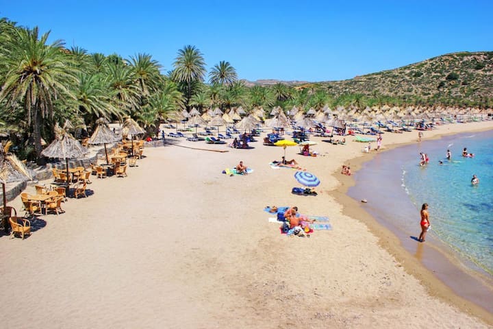
Vai is located 178km east of Queen Aikaterini apartments, 94km east of Agios Nikolaos and 24km east of Sitia. It is the most famous beach in east Crete, as its main feature is the large palm grove with the Cretan Date Palm (Phoenix theophrasti). Its name derives from the word vai, meaning palm in Greek. The palm grove is the largest in Europe with approximately 5000 trees, while there are smaller colonies in other parts of Crete and in Southwest Turkey. According to the legend, the trees have grown from discarded date stones thrown into the sea by Saracen pirates. However, the palm grove is more than 2000 years old and the pirates are more recent. Thus this hypothesis has changed and the Saracens have been replaced with Phoenicians, that governed the Mediterranean Sea 20 centuries ago.
The heavenly palm grove is planted in a wide valley watered by the local river for centuries. An exotic sandy beach with whitish sand is formed near the shore, backed by the edenic palm forest, reminding of African and Caribbean seascapes. The entire region is owned by the powerful Toplou Monastery, which is the largest landowner in eastern Crete. The 15th-century monastery is built like a fortress, and hosts a great collection of Byzantine icons.
Vai was totally unknown until the early 1970s, when a popular commercial for the Bounty chocolate with coconut was filmed here, using the magical background of palm trees. In the advert, coconuts were falling from trees, however Vai palms produce dates. Consequently coconuts had to be falsely hung to create the right impression. The ad made this unknown earthly paradise renowned throughout the world. Thus, hundreds of hippies started to stay here on their holidays. In the 1980s, when hippism faded out, Vai was invaded by backpackers and rapidly degenerated into a rubbish-strewn campground. The palm grove was consequently fenced off and proclaimed a conservation area, being open to public only during the day light.
The beach has whitish sand and flat turquoise waters. In a few places, there are slippery smooth rocks, while on the opposite there are small islets that beautify the landscape. The beach is slightly organized (whatever the protection scheme allows) with umbrellas, showers, water sports and a canteen. The closest rooms to let are located outside the protected area (15'-25 'walk). If you want to stay isolated, there is a lovely sandy beach 5 minutes north of Vai, while another option is the idyllic Psili Ammos beach in the south.
If you come by car then you should leave it in the parking area. There are also buses running from Sitia and all travel agencies in Crete organize daily tours. The only drawback of Vai is that from the first moment you think that someone wants to dip into your pocket. Indeed, prices for parking, umbrellas and the canteen are too high. However, Vai is one of the most special beaches in Crete that surely deserve a visit.
94 místní doporučují
Vydejte se na pláž
Eparchiaki Odos Monis Toplous - VaiVai is located 178km east of Queen Aikaterini apartments, 94km east of Agios Nikolaos and 24km east of Sitia. It is the most famous beach in east Crete, as its main feature is the large palm grove with the Cretan Date Palm (Phoenix theophrasti). Its name derives from the word vai, meaning palm in Greek. The palm grove is the largest in Europe with approximately 5000 trees, while there are smaller colonies in other parts of Crete and in Southwest Turkey. According to the legend, the trees have grown from discarded date stones thrown into the sea by Saracen pirates. However, the palm grove is more than 2000 years old and the pirates are more recent. Thus this hypothesis has changed and the Saracens have been replaced with Phoenicians, that governed the Mediterranean Sea 20 centuries ago.
The heavenly palm grove is planted in a wide valley watered by the local river for centuries. An exotic sandy beach with whitish sand is formed near the shore, backed by the edenic palm forest, reminding of African and Caribbean seascapes. The entire region is owned by the powerful Toplou Monastery, which is the largest landowner in eastern Crete. The 15th-century monastery is built like a fortress, and hosts a great collection of Byzantine icons.
Vai was totally unknown until the early 1970s, when a popular commercial for the Bounty chocolate with coconut was filmed here, using the magical background of palm trees. In the advert, coconuts were falling from trees, however Vai palms produce dates. Consequently coconuts had to be falsely hung to create the right impression. The ad made this unknown earthly paradise renowned throughout the world. Thus, hundreds of hippies started to stay here on their holidays. In the 1980s, when hippism faded out, Vai was invaded by backpackers and rapidly degenerated into a rubbish-strewn campground. The palm grove was consequently fenced off and proclaimed a conservation area, being open to public only during the day light.
The beach has whitish sand and flat turquoise waters. In a few places, there are slippery smooth rocks, while on the opposite there are small islets that beautify the landscape. The beach is slightly organized (whatever the protection scheme allows) with umbrellas, showers, water sports and a canteen. The closest rooms to let are located outside the protected area (15'-25 'walk). If you want to stay isolated, there is a lovely sandy beach 5 minutes north of Vai, while another option is the idyllic Psili Ammos beach in the south.
If you come by car then you should leave it in the parking area. There are also buses running from Sitia and all travel agencies in Crete organize daily tours. The only drawback of Vai is that from the first moment you think that someone wants to dip into your pocket. Indeed, prices for parking, umbrellas and the canteen are too high. However, Vai is one of the most special beaches in Crete that surely deserve a visit.
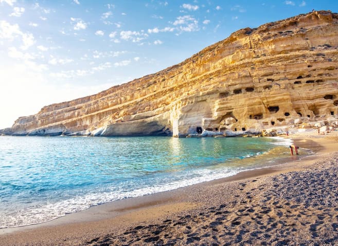
Matala is located 68km southwest of Queen Aikaterini apartments and Heraklion, where the plain Messara meets Asteroussia Mountains. This is one of the most popular tourist destinations of Crete and certainly the most famous beach of south Heraklion prefecture. It is famous for the carved caves in the rocks and the hippies of the ‘70s. It is located close to Phaestus, the second largest palace of the Minoan civilization. Matala served as a port of Phaestus, and on the Roman Times, it became a port of Gortyn.
Matala is located at the exit of a small valley, which forms an enclosed bay with nice view to the islands of Paximadia.There is a beautiful sandy beach, 300m long, with fine gravel and crystal clear deep water. Moreover, the seabed is quite rocky in some places (especially in the central part of the bach) and waves are common, due to frequent west winds. Furthermore, there is a huge cave on the north part of the beach, from the top of which some people dive. The beach is very well organized with umbrellas, toilets, showers, lifeguard, first aids, beach volley courts, snack bars, water sports, excursion boats, a camping site, etc. Around Matala you will find many options for accommodation, entertainment and eating. Also, a large part of the beach is covered by tamarisk trees, where you can find shade. In the evenings, the bars on the beach are full with many people, both locals and foreigners. Especially in June, the internationally renowned Matala Festival takes place.
THE HIPPIE CAVES OF MATALA
The most famous feature of the area are the many graves of the Roman and the Christian Era, carved in the soft white limestone thousands of years ago in the northwest walls of the bay. There are several underwater caves, as well. Many of them have rooms, stairs, beds or windows, suggesting that they were once used as residences. The hippies of the '60s and '70s found their paradise in these caves, when they visited and stayed in Matala. Hippies expressed themselves freely, enjoyed love and creation. The hallmark of the hippies was the two fingers of victory, followed by the slogan «Peace Man». Around that time there was absolutely nothing in the area, but a small fishing village for the inhabitants of Pitsidia village, so the sense of freedom was unlimited. Matala became so popular with hippies that attracted several celebrities such as Joni Mitchell (sang a song for Matala called “Carey”), Bob Dylan, Janis Joplin and Joan Baez. However, all that stopped abruptly during the Greek dictatorship (‘70s), when the local Church expelled the "shameful" hippies. Then the “children of the flowers” moved to other regions of Crete (Preveli, Plakias, Lendas, Vai), but most of them moved in Ios island, in Cyclades, and continued their happy life. Matala were abandoned for a long time and the Archaeology sealed the area with the caves.
In recent decades, the region has faced a rapid development and does not remind anything of the atmosphere of the past. Today you will see thousands of people, enjoying swimming on the beach, surrounded by modern hotels and talking about the lost past times. The caves are open to visitors as an archaeological site, but it’s forbidden to stay there overnight.
SURROUNDINGS
Along the coast there are more natural caves, which are accessible by boat. Moreover, many archaeological sites and shipwrecks have been found in the surrounding area. The Cape south of Matala is believed to be the Cape Nysos, i.e. the point where the ships of Menelaus were wrecked (according to Odyssey). Southeast of the village, there are ruins of an ancient temple, and near the beach, a marble urn has been excavated. As we said, Matala were a port of Phaestus and Gortys. Thus, ruins of the ancient sunken city have been found in the sea and some small mansions nearby. Furthermore, on the opposite side of the village, over the hill Kastri, there are ruins of a fort, said Koules, and the ruins of a beacon, a place with fire for signaling over land that enemy troops were approaching. Finally, in a cave nearby, you can visit the old church of Virgin Mary, which was a catacomb during the Christian persecutions. All of this historical and natural heritage has helped to protect the region under the international program Natura 2000.
185 místní doporučují
Matala Caves
Matala is located 68km southwest of Queen Aikaterini apartments and Heraklion, where the plain Messara meets Asteroussia Mountains. This is one of the most popular tourist destinations of Crete and certainly the most famous beach of south Heraklion prefecture. It is famous for the carved caves in the rocks and the hippies of the ‘70s. It is located close to Phaestus, the second largest palace of the Minoan civilization. Matala served as a port of Phaestus, and on the Roman Times, it became a port of Gortyn.
Matala is located at the exit of a small valley, which forms an enclosed bay with nice view to the islands of Paximadia.There is a beautiful sandy beach, 300m long, with fine gravel and crystal clear deep water. Moreover, the seabed is quite rocky in some places (especially in the central part of the bach) and waves are common, due to frequent west winds. Furthermore, there is a huge cave on the north part of the beach, from the top of which some people dive. The beach is very well organized with umbrellas, toilets, showers, lifeguard, first aids, beach volley courts, snack bars, water sports, excursion boats, a camping site, etc. Around Matala you will find many options for accommodation, entertainment and eating. Also, a large part of the beach is covered by tamarisk trees, where you can find shade. In the evenings, the bars on the beach are full with many people, both locals and foreigners. Especially in June, the internationally renowned Matala Festival takes place.
THE HIPPIE CAVES OF MATALA
The most famous feature of the area are the many graves of the Roman and the Christian Era, carved in the soft white limestone thousands of years ago in the northwest walls of the bay. There are several underwater caves, as well. Many of them have rooms, stairs, beds or windows, suggesting that they were once used as residences. The hippies of the '60s and '70s found their paradise in these caves, when they visited and stayed in Matala. Hippies expressed themselves freely, enjoyed love and creation. The hallmark of the hippies was the two fingers of victory, followed by the slogan «Peace Man». Around that time there was absolutely nothing in the area, but a small fishing village for the inhabitants of Pitsidia village, so the sense of freedom was unlimited. Matala became so popular with hippies that attracted several celebrities such as Joni Mitchell (sang a song for Matala called “Carey”), Bob Dylan, Janis Joplin and Joan Baez. However, all that stopped abruptly during the Greek dictatorship (‘70s), when the local Church expelled the "shameful" hippies. Then the “children of the flowers” moved to other regions of Crete (Preveli, Plakias, Lendas, Vai), but most of them moved in Ios island, in Cyclades, and continued their happy life. Matala were abandoned for a long time and the Archaeology sealed the area with the caves.
In recent decades, the region has faced a rapid development and does not remind anything of the atmosphere of the past. Today you will see thousands of people, enjoying swimming on the beach, surrounded by modern hotels and talking about the lost past times. The caves are open to visitors as an archaeological site, but it’s forbidden to stay there overnight.
SURROUNDINGS
Along the coast there are more natural caves, which are accessible by boat. Moreover, many archaeological sites and shipwrecks have been found in the surrounding area. The Cape south of Matala is believed to be the Cape Nysos, i.e. the point where the ships of Menelaus were wrecked (according to Odyssey). Southeast of the village, there are ruins of an ancient temple, and near the beach, a marble urn has been excavated. As we said, Matala were a port of Phaestus and Gortys. Thus, ruins of the ancient sunken city have been found in the sea and some small mansions nearby. Furthermore, on the opposite side of the village, over the hill Kastri, there are ruins of a fort, said Koules, and the ruins of a beacon, a place with fire for signaling over land that enemy troops were approaching. Finally, in a cave nearby, you can visit the old church of Virgin Mary, which was a catacomb during the Christian persecutions. All of this historical and natural heritage has helped to protect the region under the international program Natura 2000.
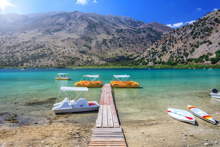
Lake Kournas is the largest natural lake in Crete and is located in an enchanting landscape, between the west slopes of the White Mountains and the fertile plane of Georgioupolis. It is located near the village Kournas, 2.5km south of the beach of Georgioupolis, 43km east of Chania and 85km west of Queen Aikaterini. Lake Kournas and its surroundings constitute a very important ecosystem for Greece, as the wider area of Apokoronas is one of the very few areas of Crete where plenty of fresh water is stored throughout the year.
The name Kournas is believed to come from the Arabic word kurna for "lake" or "bath". In ancient manuscripts it is mentioned as Korissia, while it is believed that the area hosted a sanctuary dedicated to Korissia Athena.
The lake is created by the accumulation of groundwater coming from the White Mountains. The water gushes from a spring called Amati or Mati (meaning “eye”), which is over the lake surface in the summer months, while it’s hidden below the surface during winter. There is a second spring, which is always underneath the surface. Essentially, Kournas Lake is a large pit that is fed from its southeastern side by water due to the porous grounds, while from the opposite site it is waterproofed due to the nature of the rocks.
LAKE CREATION
The lake is small and circular and covers an area of 57.9 hectares, has maximum depth 22.5 m, maximum length 1080m and maximum width of 880m. The volume of water in summer is approximately 7.5 million cubic meters. The water is transported to the beach of Kavros via the river Delfinas. In some parts of the lake, overflow and drainage works can be seen, that are used for diverting water to the farmland.
WHAT TO SEE
Lake Kournas is a favorite destination for visitors of Crete and locals. It is an ideal place for relaxation and a walk. In summer, a stroll around the turquoise lake lasts less than an hour (3.5 km). On one side of the lake there are cafes and restaurants overlooking the lake, however they have spoilt the scenery. Adjacent to the cafes, small sandy beaches are formed during the summer, as the water surface reached lower levels.
Moreover, visitors could either pedal or kayak in the lake. This is an ideal choice for the afternoon, when the color of the water is beautiful and the lake is very calm. During winter and spring the water level is higher and walking around the lake is difficult because the vegetation is dense the bank. The beaches are disappearing and water overwhelms even the stairs located next to the restaurants.
361 místní doporučují
Jezero Kournas
Lake Kournas is the largest natural lake in Crete and is located in an enchanting landscape, between the west slopes of the White Mountains and the fertile plane of Georgioupolis. It is located near the village Kournas, 2.5km south of the beach of Georgioupolis, 43km east of Chania and 85km west of Queen Aikaterini. Lake Kournas and its surroundings constitute a very important ecosystem for Greece, as the wider area of Apokoronas is one of the very few areas of Crete where plenty of fresh water is stored throughout the year.
The name Kournas is believed to come from the Arabic word kurna for "lake" or "bath". In ancient manuscripts it is mentioned as Korissia, while it is believed that the area hosted a sanctuary dedicated to Korissia Athena.
The lake is created by the accumulation of groundwater coming from the White Mountains. The water gushes from a spring called Amati or Mati (meaning “eye”), which is over the lake surface in the summer months, while it’s hidden below the surface during winter. There is a second spring, which is always underneath the surface. Essentially, Kournas Lake is a large pit that is fed from its southeastern side by water due to the porous grounds, while from the opposite site it is waterproofed due to the nature of the rocks.
LAKE CREATION
The lake is small and circular and covers an area of 57.9 hectares, has maximum depth 22.5 m, maximum length 1080m and maximum width of 880m. The volume of water in summer is approximately 7.5 million cubic meters. The water is transported to the beach of Kavros via the river Delfinas. In some parts of the lake, overflow and drainage works can be seen, that are used for diverting water to the farmland.
WHAT TO SEE
Lake Kournas is a favorite destination for visitors of Crete and locals. It is an ideal place for relaxation and a walk. In summer, a stroll around the turquoise lake lasts less than an hour (3.5 km). On one side of the lake there are cafes and restaurants overlooking the lake, however they have spoilt the scenery. Adjacent to the cafes, small sandy beaches are formed during the summer, as the water surface reached lower levels.
Moreover, visitors could either pedal or kayak in the lake. This is an ideal choice for the afternoon, when the color of the water is beautiful and the lake is very calm. During winter and spring the water level is higher and walking around the lake is difficult because the vegetation is dense the bank. The beaches are disappearing and water overwhelms even the stairs located next to the restaurants.
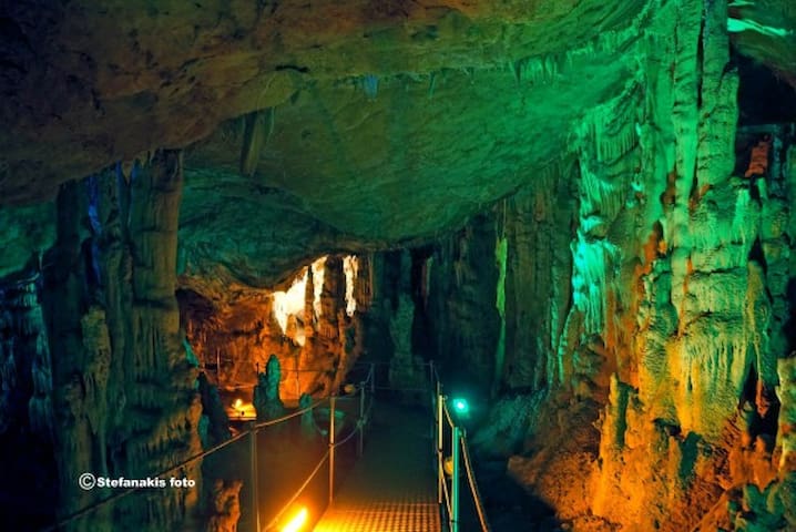
#You can combine this with the Gorge Zoniana
Cave Zoniana, Sfendoni or Sfendoni's Hole, is located 1km north of Zoniana village in Mylopotamos, about 43km west of Heraklion (Queen Aikaterini). It is shaped on the southern slopes of the hill Halepa at an altitude of 630m. The cave is accessible and is the most beautiful cave in Crete and one of the most beautiful in Greece, with rich stalactite and stalagmite decoration. It belongs to the Natural Park of Psiloritis, which is protected by UNESCO.
It has been exploited for tourism and you will need to pay a cheap ticket. Information on exact ticket prices and opening hours of the cave, you will find on the website of Zoniana. You will need an experienced guide from Zoniana to accompany you, for your safety and the cave, who will give you all the information about the cave. The route in the cave is signed by metal corridors, fitted with ropes, for greater security. These are accessible even by persons with disabilities.
The cave has an area of 3000 sq. m, and is one of the most beautiful in Greece. Visitors however are allowed only to visit two-thirds of it, walking along a corridor of about 270 meters. The maximum length of the cave is 145m. There are huge columns that create labyrinthine compartments inside the cave. Many stalactites and stalagmites of different colors and shapes decorate the 14 rooms of the cave. In several places, there are water basins. Also you can see the so-called "cave pearls”, a type of speleothem, a concretion of calcium salts which forms in limestone caves and resemble pearls. Finally, the glow coming from the tiny crystals of calcium carbonate is particularly impressive.
The cave is home to four species of bats and dozens of species of invertebrates (snails, spiders, false-scorpions, woodlices, millipedes, spring tails, cave crickets etc.). Some of those are colorless and blind, while at least two species are cave’s endemics. The cave also has high archaeological importance. Excavations have shown that it was used occasionally by shepherds for thousands of years. Pottery dating has indicated that there was continuous, but not intense use of the cave, from Neolithic times till today.
Many years ago, in the last chamber of the cave, a skeleton belonging to a small child was discovered. It was covered with limestone material, denoting that it had been left there for several centuries. It is likely that the child entered the cave and missed the exit in the cave mazes. Many locals believe that it is the boy who was killed by Sfendonis’ boot.
The cave of Zoniana is called by locals as the "Sfendonis’ Hole”. The name comes from a rebel from Sfakia, called Sfendonis, who was hiding in the cave.One day, while cooking meat near the entrance of the cave, a boy approached him to ask him some food. Sfendonis got furious because his hideout was revealed and kicked the boy with his boot so hard that he killed him.
According to legend, a beautiful fairy lived in the cave. Every day, at a certain time, the fairy came out of the cave and went to drink water in a nearby spring. A shepherd saw her several times and fell in love, but she always escaped in the cave. He decided to be watch her. When she passed nearby, he hurt her with his sling (Sfendona means “sling” in Greek). The wounded fairy managed to run and got lost in the cave, but her bloody handkerchief was dropped at the entrance of the cave, where the shepherd found it. Another legend says that the shepherd approached the wounded nymph and tried to kiss her. She prevented him and promised him a rod with silk which will never dry up, if he would not kiss her. However, shepherd kissed her and she cursed him. The cursed shepherd’s and his family hands’ were trembling forever.
Entrance Fee (€): 5
Phone: 0030 28340 61734, 0030 28340 61869, 0030 28340 61209
79 místní doporučují
Jeskyně Sfendoni v Zoniana
#You can combine this with the Gorge Zoniana
Cave Zoniana, Sfendoni or Sfendoni's Hole, is located 1km north of Zoniana village in Mylopotamos, about 43km west of Heraklion (Queen Aikaterini). It is shaped on the southern slopes of the hill Halepa at an altitude of 630m. The cave is accessible and is the most beautiful cave in Crete and one of the most beautiful in Greece, with rich stalactite and stalagmite decoration. It belongs to the Natural Park of Psiloritis, which is protected by UNESCO.
It has been exploited for tourism and you will need to pay a cheap ticket. Information on exact ticket prices and opening hours of the cave, you will find on the website of Zoniana. You will need an experienced guide from Zoniana to accompany you, for your safety and the cave, who will give you all the information about the cave. The route in the cave is signed by metal corridors, fitted with ropes, for greater security. These are accessible even by persons with disabilities.
The cave has an area of 3000 sq. m, and is one of the most beautiful in Greece. Visitors however are allowed only to visit two-thirds of it, walking along a corridor of about 270 meters. The maximum length of the cave is 145m. There are huge columns that create labyrinthine compartments inside the cave. Many stalactites and stalagmites of different colors and shapes decorate the 14 rooms of the cave. In several places, there are water basins. Also you can see the so-called "cave pearls”, a type of speleothem, a concretion of calcium salts which forms in limestone caves and resemble pearls. Finally, the glow coming from the tiny crystals of calcium carbonate is particularly impressive.
The cave is home to four species of bats and dozens of species of invertebrates (snails, spiders, false-scorpions, woodlices, millipedes, spring tails, cave crickets etc.). Some of those are colorless and blind, while at least two species are cave’s endemics. The cave also has high archaeological importance. Excavations have shown that it was used occasionally by shepherds for thousands of years. Pottery dating has indicated that there was continuous, but not intense use of the cave, from Neolithic times till today.
Many years ago, in the last chamber of the cave, a skeleton belonging to a small child was discovered. It was covered with limestone material, denoting that it had been left there for several centuries. It is likely that the child entered the cave and missed the exit in the cave mazes. Many locals believe that it is the boy who was killed by Sfendonis’ boot.
The cave of Zoniana is called by locals as the "Sfendonis’ Hole”. The name comes from a rebel from Sfakia, called Sfendonis, who was hiding in the cave.One day, while cooking meat near the entrance of the cave, a boy approached him to ask him some food. Sfendonis got furious because his hideout was revealed and kicked the boy with his boot so hard that he killed him.
According to legend, a beautiful fairy lived in the cave. Every day, at a certain time, the fairy came out of the cave and went to drink water in a nearby spring. A shepherd saw her several times and fell in love, but she always escaped in the cave. He decided to be watch her. When she passed nearby, he hurt her with his sling (Sfendona means “sling” in Greek). The wounded fairy managed to run and got lost in the cave, but her bloody handkerchief was dropped at the entrance of the cave, where the shepherd found it. Another legend says that the shepherd approached the wounded nymph and tried to kiss her. She prevented him and promised him a rod with silk which will never dry up, if he would not kiss her. However, shepherd kissed her and she cursed him. The cursed shepherd’s and his family hands’ were trembling forever.
Entrance Fee (€): 5
Phone: 0030 28340 61734, 0030 28340 61869, 0030 28340 61209