
Liam’s guidebook
Sightseeing
Just a 10 minute drive (15km) east of Old School Rocky Cape. If you enjoy a quiet bay with white sands and clear water, then Boat Harbour is guaranteed to steal your heart. The area has two small population centres – the town, high above sea-level, and the small beach community below, nestled between rocky headlands. The beach is what it's all about, with family-friendly waves, rock pools to explore, pacific gulls and clean white sand. From the winding road that descends to the water, the views of the harbour are captivating. Keep an eye out for dolphins, seals and whales that occasionally enter the bay area. Boat Harbour was voted one of Australia's top ten beaches.
39 místní doporučují
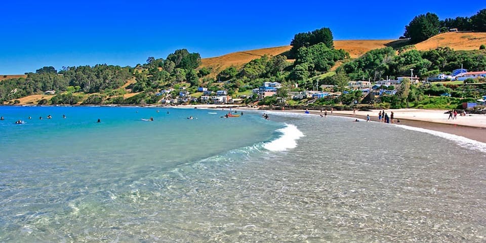
Boat Harbour Beach
Just a 10 minute drive (15km) east of Old School Rocky Cape. If you enjoy a quiet bay with white sands and clear water, then Boat Harbour is guaranteed to steal your heart. The area has two small population centres – the town, high above sea-level, and the small beach community below, nestled between rocky headlands. The beach is what it's all about, with family-friendly waves, rock pools to explore, pacific gulls and clean white sand. From the winding road that descends to the water, the views of the harbour are captivating. Keep an eye out for dolphins, seals and whales that occasionally enter the bay area. Boat Harbour was voted one of Australia's top ten beaches.
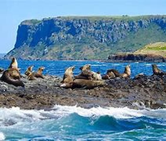
One of the most unique experiences you can have in North West Tasmania is taking a Seal Cruise. Stanley Seal Cruises is a way to see to the Australian Fur Seal in Tasmania.
This involves a 75 minute boat trip from the harbour to Bull Rock, Calf Rock and Cow Rock, appropriately named based on their size. It is on these isolated rocks in Bass Strait that you are very likely to witness a gathering of seals. This is what makes the location so ideal for seal cruises.
In addition to the seals it is a great experience for bird watchers, and it is also not rare to see the Southern Right Whale which is both incredible and daunting – their size could easily topple the boat.
This time of year is definitely the best time to take a seal cruise. Around November and December, the seals pups are born and the rocks are flooding with baby seals – a very cute sight to see.
contact details at the Stanley Seal Cruises website.
Stanley Seal Cruises
6 Wharf RdOne of the most unique experiences you can have in North West Tasmania is taking a Seal Cruise. Stanley Seal Cruises is a way to see to the Australian Fur Seal in Tasmania.
This involves a 75 minute boat trip from the harbour to Bull Rock, Calf Rock and Cow Rock, appropriately named based on their size. It is on these isolated rocks in Bass Strait that you are very likely to witness a gathering of seals. This is what makes the location so ideal for seal cruises.
In addition to the seals it is a great experience for bird watchers, and it is also not rare to see the Southern Right Whale which is both incredible and daunting – their size could easily topple the boat.
This time of year is definitely the best time to take a seal cruise. Around November and December, the seals pups are born and the rocks are flooding with baby seals – a very cute sight to see.
contact details at the Stanley Seal Cruises website.
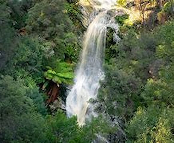
It's easy to overlook, but Dip Falls is one of the most beautiful in the state. It's two-tiered structure and unique rock formations make it well worth a visit.
From the parking area next to the falls in the Dip Falls Reserve, it's a short walk to a platform with an unsurpassed view out over the top of the falls. Another path leads down some steps to the base of the falls and its unique rock formations.
Like other waterfalls, Dip Falls is at its most impressive after rain and is best viewed in winter. From the car park you can also walk 5 min to the Big Tree in the Big Tree Reserve. The circumference of the tree at its base is nearly 17 m and definitely worth a look if you're here.
Dip Falls is between Rocky Cape and Stanley in Tasmania's North West, 27 km up a quiet and mostly sealed road that passes through pleasant countryside.
Both the falls and Big Tree Reserve are suitable for disabled access. BBQ facilities and toilets are provided.
Dip Falls Forest Reserve
It's easy to overlook, but Dip Falls is one of the most beautiful in the state. It's two-tiered structure and unique rock formations make it well worth a visit.
From the parking area next to the falls in the Dip Falls Reserve, it's a short walk to a platform with an unsurpassed view out over the top of the falls. Another path leads down some steps to the base of the falls and its unique rock formations.
Like other waterfalls, Dip Falls is at its most impressive after rain and is best viewed in winter. From the car park you can also walk 5 min to the Big Tree in the Big Tree Reserve. The circumference of the tree at its base is nearly 17 m and definitely worth a look if you're here.
Dip Falls is between Rocky Cape and Stanley in Tasmania's North West, 27 km up a quiet and mostly sealed road that passes through pleasant countryside.
Both the falls and Big Tree Reserve are suitable for disabled access. BBQ facilities and toilets are provided.
is a wild and desolate place, beset by churning seas. Rolling waves drag pieces of driftwood the size of whole tree trunks onto the windswept beach. The bare logs are washed by the wind and currents into neat stacks on the sand, bringing a whiff of order to the mayhem. There's no land between this solitary stretch of the Tasmanian coast and Argentina, making it the longest uninterrupted expanse of ocean on Earth.
Located an hours drive from Rocky Cape, at Gardiners Point just south of the Arthur River, it makes a great day out for a picnic lunch and scenic drive. With a new enclosed BBQ area, it is the perfect place to take your lunch and have a cook up before continuing on your journey.
Edge Of the World
is a wild and desolate place, beset by churning seas. Rolling waves drag pieces of driftwood the size of whole tree trunks onto the windswept beach. The bare logs are washed by the wind and currents into neat stacks on the sand, bringing a whiff of order to the mayhem. There's no land between this solitary stretch of the Tasmanian coast and Argentina, making it the longest uninterrupted expanse of ocean on Earth.
Located an hours drive from Rocky Cape, at Gardiners Point just south of the Arthur River, it makes a great day out for a picnic lunch and scenic drive. With a new enclosed BBQ area, it is the perfect place to take your lunch and have a cook up before continuing on your journey.
Every spring between mid September and mid October the Tulip Fields of the Van Diemen Bulb Farm burst into colour. The pictures tell the story. There is a nominal entry fee. When travelling from Rocky Cape on the Bass HWY, there are signs on the side of the road. Just follow the signs. Occasionally some tulips are grown in the farm fields outside Boat Harbour, so you can see them on your normal travel.
Van Diemen Quality Bulbs
363 Table Cape Rd
Every spring between mid September and mid October the Tulip Fields of the Van Diemen Bulb Farm burst into colour. The pictures tell the story. There is a nominal entry fee. When travelling from Rocky Cape on the Bass HWY, there are signs on the side of the road. Just follow the signs. Occasionally some tulips are grown in the farm fields outside Boat Harbour, so you can see them on your normal travel.
Although not part of Rocky Cape National Park, they are a short drive from the eastern end of the park. 9 kilometres south of Sisters Creek through the rich green pastures of the North West are the superb Detention Falls. Turn left towards Meuna then right at Hawleys Road. Only a short 10 minute walk takes you to a well constructed viewing platform.
The track has recently been upgraded making in one of Tasmania's great short walks. The adventurous can venture down to the valley floor. The tannin in the water gives the water a pink hue.
Detention Falls Conservation Area
Although not part of Rocky Cape National Park, they are a short drive from the eastern end of the park. 9 kilometres south of Sisters Creek through the rich green pastures of the North West are the superb Detention Falls. Turn left towards Meuna then right at Hawleys Road. Only a short 10 minute walk takes you to a well constructed viewing platform.
The track has recently been upgraded making in one of Tasmania's great short walks. The adventurous can venture down to the valley floor. The tannin in the water gives the water a pink hue.
Friends of Burnie Penguins provide a free interpretative guided experience to visitors to the Burnie Little Penguin colony. You will have an opportunity for an intimate view into the seasonal life of penguin families from courtship, through to chick rearing and to moulting adults at the end of the breeding season.
The colony is located along the foreshore in Burnie a very short distance from the city centre, you can walk to the Penguin Observation Centre along boardwalk from your hotel, or park in the area behind the Makers Workshop. The viewing area is level with wheelchair access and is child friendly.
15 místní doporučují
Little Penguin Observation Center
Friends of Burnie Penguins provide a free interpretative guided experience to visitors to the Burnie Little Penguin colony. You will have an opportunity for an intimate view into the seasonal life of penguin families from courtship, through to chick rearing and to moulting adults at the end of the breeding season.
The colony is located along the foreshore in Burnie a very short distance from the city centre, you can walk to the Penguin Observation Centre along boardwalk from your hotel, or park in the area behind the Makers Workshop. The viewing area is level with wheelchair access and is child friendly.
Striking rock formations, an incredible variety of flowering plants and important Aboriginal heritage all make this park, on the shores of Bass Strait in Tasmania’s far north-west, worth exploring. Gnarly rocks contrast with the wild blue ocean and waves pound the coast with intensity, sending up a salty sea spray that fills the air as you meander along the rugged coastline.
Tucked around the small hamlets of Boat Harbour and Sisters Beach, Rocky Cape National Park is mainly a day use park and is best discovered on foot. Choose from short easy strolls or longer day walks into the less-travelled parts of this park, taking in scenic hills, tranquil bays and rocky headlands.
25 místní doporučují
Rocky Cape National Park
Striking rock formations, an incredible variety of flowering plants and important Aboriginal heritage all make this park, on the shores of Bass Strait in Tasmania’s far north-west, worth exploring. Gnarly rocks contrast with the wild blue ocean and waves pound the coast with intensity, sending up a salty sea spray that fills the air as you meander along the rugged coastline.
Tucked around the small hamlets of Boat Harbour and Sisters Beach, Rocky Cape National Park is mainly a day use park and is best discovered on foot. Choose from short easy strolls or longer day walks into the less-travelled parts of this park, taking in scenic hills, tranquil bays and rocky headlands.
The Tarkine is located in the northwest of Tasmania in a relatively untouched region. Despite not having recognized and mapped borders, the Tarkine Region is generally agreed to be located in an area bordered by Arthur River to the north, the Pieman River to the south and the Murchison Highway to the east.
The little town of Arthur River at the western most point of Tasmania is a 2 hour drive from Burnie on the northwest Coast and from Zeehan the small settlement of Corinna is approximately a 50 kilometer drive via unsealed road. These two townships are most commonly associated with the Tarkine and give visitors access into this special region.
Tarkine Wilderness Walk
1 Corinna RdThe Tarkine is located in the northwest of Tasmania in a relatively untouched region. Despite not having recognized and mapped borders, the Tarkine Region is generally agreed to be located in an area bordered by Arthur River to the north, the Pieman River to the south and the Murchison Highway to the east.
The little town of Arthur River at the western most point of Tasmania is a 2 hour drive from Burnie on the northwest Coast and from Zeehan the small settlement of Corinna is approximately a 50 kilometer drive via unsealed road. These two townships are most commonly associated with the Tarkine and give visitors access into this special region.
Marrawah is 100km West of Rocky Cape, via Smithton and is Tasmania's westernmost community and the furthest settlement from Hobart. Marrawah is the most popular surfing spot in Tasmania’s north. Marrawah is accessed from Tasmania's north west region. Marrawah's three beaches - Ann Bay, Mawson Bay and Green Point - have hundred-metre-long rides when the swell is westerly and the wind offshore. The record wave in this area was measured at almost 20 metres with wind and surf rolling in uninterrupted for almost 17,000 kilometres.
Marrawah is the venue for the National Wave Sailing Championships; a highly sought after title worth $22,000 and held over 5-days in February that combines wind and wave skills to attract competitors and visitors. The West Coast Surf Classic, an amateur surf carnival that has been going for the past 30 years, follows this event each March long weekend and attracts up to 1000 spectators and competitors.
Marrawah Tavern
821 Comeback RdMarrawah is 100km West of Rocky Cape, via Smithton and is Tasmania's westernmost community and the furthest settlement from Hobart. Marrawah is the most popular surfing spot in Tasmania’s north. Marrawah is accessed from Tasmania's north west region. Marrawah's three beaches - Ann Bay, Mawson Bay and Green Point - have hundred-metre-long rides when the swell is westerly and the wind offshore. The record wave in this area was measured at almost 20 metres with wind and surf rolling in uninterrupted for almost 17,000 kilometres.
Marrawah is the venue for the National Wave Sailing Championships; a highly sought after title worth $22,000 and held over 5-days in February that combines wind and wave skills to attract competitors and visitors. The West Coast Surf Classic, an amateur surf carnival that has been going for the past 30 years, follows this event each March long weekend and attracts up to 1000 spectators and competitors.
The Trowutta Arch State Reserve is a beautiful area of luscious Tasmanian rain-forest. The main attraction, named the Trowutta Arch, is a giant rock arch which appears like a shallow cave with an opening at either side. There is a piece of water with a green appearance and a beautiful surrounding of natural rain-forest.
Many people visit the Trowutta Arch from Rocky Cape, which is a 1 hour, 90 kilometre drive. Take the Bass Highway to Smithton then turn left, taking the Trowutta Road to Trowutta. Turn left onto Reids Road then right shortly after onto Reynolds Road, then left onto Gun Road.
Trowutta Caves State Reserve
The Trowutta Arch State Reserve is a beautiful area of luscious Tasmanian rain-forest. The main attraction, named the Trowutta Arch, is a giant rock arch which appears like a shallow cave with an opening at either side. There is a piece of water with a green appearance and a beautiful surrounding of natural rain-forest.
Many people visit the Trowutta Arch from Rocky Cape, which is a 1 hour, 90 kilometre drive. Take the Bass Highway to Smithton then turn left, taking the Trowutta Road to Trowutta. Turn left onto Reids Road then right shortly after onto Reynolds Road, then left onto Gun Road.
Cradle Mountain is 140km Southeast of Rocky Cape. It is situated in the Cradle Mountain-Lake St Clair World Heritage National Park. The park contains many walking trails and is where hikes along the well-known Overland Track begin. The park is known for its diverse and breathtaking landscapes including moss-covered ancient rain forests, deep river gorges, snow covered mountain peaks, wild alpine moorlands and glacial lakes.
17 místní doporučují
Národní park Cradle Mountain-Lake St Clair
Cradle Mountain is 140km Southeast of Rocky Cape. It is situated in the Cradle Mountain-Lake St Clair World Heritage National Park. The park contains many walking trails and is where hikes along the well-known Overland Track begin. The park is known for its diverse and breathtaking landscapes including moss-covered ancient rain forests, deep river gorges, snow covered mountain peaks, wild alpine moorlands and glacial lakes.
Heading off the beaten track and into the wilderness, The Tarkine Drive in Tasmania's north-west is now easily accessible for anyone wanting to get back in touch with nature and experience the wilderness. The loop through the Tarkine Drive takes travellers through natural and dramatic landscapes beginning with Kanunnah Bridge Picnic Area, taking its name from the aboriginal name for 'Tasmanian Tiger', Sumac Lookout surrounded by rain-forest and tall eucalypts and more impressive widespread views of the river and beyond. Julius River Forest Reserve has cool temperate rain-forest, excellent picnic facilities and with two walks, moderate 30 minute and 40 minute walks. Lake Chisholm Forest Reserve has flooded limestone sinkholes and meandering walks through old myrtle forests and alongside still watered lakes. At Milkshakes Hills Forest Reserve, relax with picnic spots nestled among the eucalypts. Completing the loop is the Trowutta Arch Rain Forest Walk; a stunning and natural geological structure. The Tarkine Drive starts an effortless 45km drive from Rocky Cape to Smithton. Smithton to the Tarkine Drive return is 130 km. The Tarkine Drive route is sealed and has made the drive easily accessible and much more pleasurable.
Rapid River, Tarkine Drive
Heading off the beaten track and into the wilderness, The Tarkine Drive in Tasmania's north-west is now easily accessible for anyone wanting to get back in touch with nature and experience the wilderness. The loop through the Tarkine Drive takes travellers through natural and dramatic landscapes beginning with Kanunnah Bridge Picnic Area, taking its name from the aboriginal name for 'Tasmanian Tiger', Sumac Lookout surrounded by rain-forest and tall eucalypts and more impressive widespread views of the river and beyond. Julius River Forest Reserve has cool temperate rain-forest, excellent picnic facilities and with two walks, moderate 30 minute and 40 minute walks. Lake Chisholm Forest Reserve has flooded limestone sinkholes and meandering walks through old myrtle forests and alongside still watered lakes. At Milkshakes Hills Forest Reserve, relax with picnic spots nestled among the eucalypts. Completing the loop is the Trowutta Arch Rain Forest Walk; a stunning and natural geological structure. The Tarkine Drive starts an effortless 45km drive from Rocky Cape to Smithton. Smithton to the Tarkine Drive return is 130 km. The Tarkine Drive route is sealed and has made the drive easily accessible and much more pleasurable.
Sheffield is a town in Tasmania that is famous for its murals and is 115km Southeast of Rocky Cape. The town has over 50 murals painted on the side of every building and the face of every structure in town. The murals were created by local artists and depict the community story and that of local characters past and present.
Sheffield Murals Self-Guided Walking Tour
Sheffield is a town in Tasmania that is famous for its murals and is 115km Southeast of Rocky Cape. The town has over 50 murals painted on the side of every building and the face of every structure in town. The murals were created by local artists and depict the community story and that of local characters past and present.
Stanley
Stanley is a romantic town sitting on a slender sliver of land jutting out into the Bass Strait just 15 minutes northwest from Rocky Cape along the coast. It is remarkable for its incredibly well-preserved colonial buildings and its massive volcanic plug. The plug rises 150 metres out of the water and it dominates the small town skyline.
This heavy touristed town is perfect for a romantic getaway, but the name of the volcanic plug belies Stanley's quaintness. Called "The Nut," Stanley's cheeky geological feature is what visitors remember most. The Nut offers 360° views from the top. It is a strenuous hike that takes you 150 metres above the sea where you can marvel at Tasmania's beautiful and rugged northwest coastline. Or you can opt to take the chairlift if the steep hike is too much. Be sure to look below for sea lions basking in the sun and tiny Penguins coming back from a day's hunt out in the Bass Strait.
49 místní doporučují
Stanley
Stanley is a romantic town sitting on a slender sliver of land jutting out into the Bass Strait just 15 minutes northwest from Rocky Cape along the coast. It is remarkable for its incredibly well-preserved colonial buildings and its massive volcanic plug. The plug rises 150 metres out of the water and it dominates the small town skyline.
This heavy touristed town is perfect for a romantic getaway, but the name of the volcanic plug belies Stanley's quaintness. Called "The Nut," Stanley's cheeky geological feature is what visitors remember most. The Nut offers 360° views from the top. It is a strenuous hike that takes you 150 metres above the sea where you can marvel at Tasmania's beautiful and rugged northwest coastline. Or you can opt to take the chairlift if the steep hike is too much. Be sure to look below for sea lions basking in the sun and tiny Penguins coming back from a day's hunt out in the Bass Strait.