
Arben’s guidebook sightseeing and more
Tasty Food
Taverna Te LILO
Rruga KosovaXhemal Restaurant
Restorant Titanic
Taverna Arial
Albanian Homemade Fresh Food and also Mediterranean cuisine
Novus Traditional-Food-Restaurant
Tre Forchette - Restaurant
Adriatik Restaurant
Te Fabio
Restorant 'Joni ' Vlore
Oannas Restaurant
Tasty Food
Kaço Fish Restaurant
Fish Restorante Tek Beni Meta
Neighborhoods
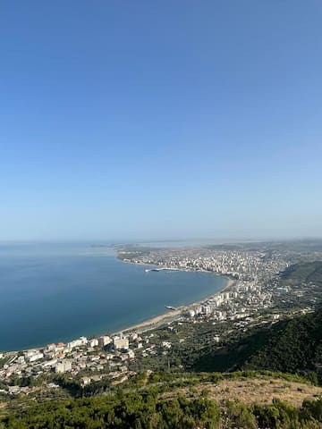
Vlorë
Muradie Neighbourhood or Vlora old Town Must be Visited
Kuzum Baba is a natural terrace carved out by the sea, located on a hill above the city of Vlore. It takes its name from Sejjid Ali Sulltan, known as Father Kuzum (Quzum Baba), a Bektashi spiritual leader, who according to local tradition, is buried here. Being the highest point of the city, somewhere at 30 m from the sea level, Kuzum Baba offers visitors the chance to enjoy the fresh air and to admire beautiful city landscapes. The 300 meters long terrace represents, despite its geological importance, a religious center for the Bekatashi sect. There is a Bektashi temple atop of the hill (Tempulli i Bektashinjve), built around 1600. The sect was influential in the 17th century, but its stopped its activity temporarily around 1826, because of local persecutions. Today however, the Tekke of Kuzum Dad (Teqeja e Kuzum Babait) is one of the most important Bekatashi centers in all Albania.
30 místní doporučují
Kuzum Baba
Kuzum Baba is a natural terrace carved out by the sea, located on a hill above the city of Vlore. It takes its name from Sejjid Ali Sulltan, known as Father Kuzum (Quzum Baba), a Bektashi spiritual leader, who according to local tradition, is buried here. Being the highest point of the city, somewhere at 30 m from the sea level, Kuzum Baba offers visitors the chance to enjoy the fresh air and to admire beautiful city landscapes. The 300 meters long terrace represents, despite its geological importance, a religious center for the Bekatashi sect. There is a Bektashi temple atop of the hill (Tempulli i Bektashinjve), built around 1600. The sect was influential in the 17th century, but its stopped its activity temporarily around 1826, because of local persecutions. Today however, the Tekke of Kuzum Dad (Teqeja e Kuzum Babait) is one of the most important Bekatashi centers in all Albania.
City/town information
Apollonia was an ancient Greek colony city and former bishopric in Illyria , located on the right bank of the Aous river (modern-day Vjosa). Its ruins are situated in the Fier region, near the village of Pojani (Polina), in modern-day Albania.
The ancient city of Apollonia is situated in southwestern Albania, about 13 miles from the city of Fier. The fascinating landscape of the archeological park, which has been preserved in an exceptionally intact condition, comprises a successful combination between the beauty of monuments and nature, attractive through its long history, in an atmosphere of relaxation and meditation. Its foundation took place immediately after the foundation of Epidamnus – Dyrrachium and quickly became one of the most eminent cities of the Adriatic basin, which was mentioned more frequently from the other 30 (thirty) cities bearing the same name during Antiquity. The city lay in the territory of the political communion of the Taulantii and was broadly known as Apollonia of Illyria. According to the tradition it was founded during the first half of the 6th century BC by Greek colonist from Corfu and Corinth, led by Gylax, which named the city after his name (Gylakeia). After its quick establishment the city changed its name to Apollonia, according to the powerful divinity Apollo. It stands on a hilly plateau from where expands the fertile plain of Musacchia with the Adriatic Sea and the hills of Mallakastra. The ruins of Apollonia are discovered in the beginning of the 19th century.
The city flourished during the 4th century AD as an important economic and trade center. Over time it was expanded over the whole hilly slope including an area of ca. 81 ha, surrounded by a large wall of 3 km of length and 3 m of width. Although Apollonia was situated few kilometers away from the Adriatic Sea, its position on the right bank of the Aoos River (modern Vjosë) enabled its communication with the coastal part of the territory. In the two hilltops dominating the city stands the temenos area (the sacred area around the temple of Apollo) and the Arx (military citadel). Between the two hilltops were situated the public buildings of the ancient city, which continued to experience a period of grandeur and splendor under the successive roman rule (since 229 BC). The fame of the city attracted many personalities of the largest empire of the ancient world as the eminent roman philosopher and orator Cicero, which noted Apollonia in his Philippics as magna urbs et gravis (a great and important city). During this period the city became one of the most important gateways of the transbalkanic Via Egnatia, while in its famous Academy has studied and underwent military training Octavianus, accompanied by Agrippas, the eminent general and statesman of the Roman Empire. After a long period of continuous economic and cultural development, Apollonia fell into decline until its total abandonment during the medieval period. The culture and the general development of the city maintained a clear Greek character throughout its existence. However, the independent economic and politic activity as well as the close relationships with the Illyrian hinterland determined a distinctive physiognomy of the apollonian culture.
This archaeologic park or site contain also a Museum of Archaeology that is situated at the old Monastery of Saint Mary .
Fier
Apollonia was an ancient Greek colony city and former bishopric in Illyria , located on the right bank of the Aous river (modern-day Vjosa). Its ruins are situated in the Fier region, near the village of Pojani (Polina), in modern-day Albania.
The ancient city of Apollonia is situated in southwestern Albania, about 13 miles from the city of Fier. The fascinating landscape of the archeological park, which has been preserved in an exceptionally intact condition, comprises a successful combination between the beauty of monuments and nature, attractive through its long history, in an atmosphere of relaxation and meditation. Its foundation took place immediately after the foundation of Epidamnus – Dyrrachium and quickly became one of the most eminent cities of the Adriatic basin, which was mentioned more frequently from the other 30 (thirty) cities bearing the same name during Antiquity. The city lay in the territory of the political communion of the Taulantii and was broadly known as Apollonia of Illyria. According to the tradition it was founded during the first half of the 6th century BC by Greek colonist from Corfu and Corinth, led by Gylax, which named the city after his name (Gylakeia). After its quick establishment the city changed its name to Apollonia, according to the powerful divinity Apollo. It stands on a hilly plateau from where expands the fertile plain of Musacchia with the Adriatic Sea and the hills of Mallakastra. The ruins of Apollonia are discovered in the beginning of the 19th century.
The city flourished during the 4th century AD as an important economic and trade center. Over time it was expanded over the whole hilly slope including an area of ca. 81 ha, surrounded by a large wall of 3 km of length and 3 m of width. Although Apollonia was situated few kilometers away from the Adriatic Sea, its position on the right bank of the Aoos River (modern Vjosë) enabled its communication with the coastal part of the territory. In the two hilltops dominating the city stands the temenos area (the sacred area around the temple of Apollo) and the Arx (military citadel). Between the two hilltops were situated the public buildings of the ancient city, which continued to experience a period of grandeur and splendor under the successive roman rule (since 229 BC). The fame of the city attracted many personalities of the largest empire of the ancient world as the eminent roman philosopher and orator Cicero, which noted Apollonia in his Philippics as magna urbs et gravis (a great and important city). During this period the city became one of the most important gateways of the transbalkanic Via Egnatia, while in its famous Academy has studied and underwent military training Octavianus, accompanied by Agrippas, the eminent general and statesman of the Roman Empire. After a long period of continuous economic and cultural development, Apollonia fell into decline until its total abandonment during the medieval period. The culture and the general development of the city maintained a clear Greek character throughout its existence. However, the independent economic and politic activity as well as the close relationships with the Illyrian hinterland determined a distinctive physiognomy of the apollonian culture.
This archaeologic park or site contain also a Museum of Archaeology that is situated at the old Monastery of Saint Mary .
Sightseeing
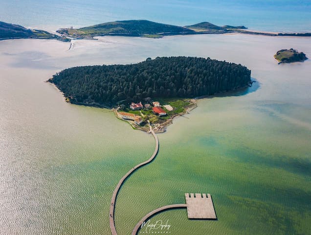
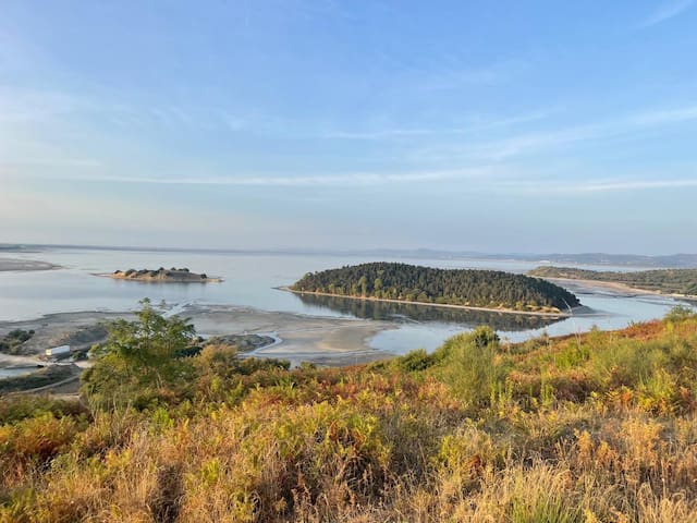
Zvërnec Island is an island within the Narta Lagoon in southern Albania. The island is nearly all covered with tall pine trees and is just east of a much smaller island. It is 430m in length and has a maximum width of 300m. Zvërnec Island is connected to the mainland by a 270m long wooden bridge
Zvërnec Islands, Albánie
Zvërnec Island is an island within the Narta Lagoon in southern Albania. The island is nearly all covered with tall pine trees and is just east of a much smaller island. It is 430m in length and has a maximum width of 300m. Zvërnec Island is connected to the mainland by a 270m long wooden bridge
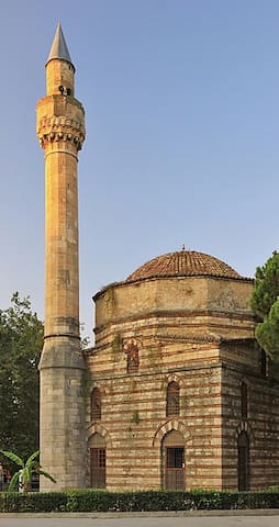
The mosque is located in downtown Vlora on a central square, surrounded on all four sides with roads. It is located on west of Sadik Zotaj, south of Lef Sallata and east of Papa Kristo Negovani streets.
Interior view of dome
The structure consists of the main building and the minaret. The former is about 10 to 11 square meters while the minaret has a length of 18 metres. In the past, it also had a portico which has been destroyed later. The mosque has a dome with a supporting polygon raised base, arched windows and classical triangular forms topping the side walls. The brick work of the Muradie mosque has layers with two different brick colors. There is also a contrast between the texture, quality, color, as well as size and sequence of the bricks used to build the Islamic prayer hall compared with the larger white chiseled stones used to build the minaret.
It is believed that the cultural monument was designed by the prominent Ottoman architect, Mimar Sinani, a leading mosque builder in the Ottoman Empire and the author of the Great Suleymaniye Mosque in Constantinople (Istanbul).
Muradie Mosque
The mosque is located in downtown Vlora on a central square, surrounded on all four sides with roads. It is located on west of Sadik Zotaj, south of Lef Sallata and east of Papa Kristo Negovani streets.
Interior view of dome
The structure consists of the main building and the minaret. The former is about 10 to 11 square meters while the minaret has a length of 18 metres. In the past, it also had a portico which has been destroyed later. The mosque has a dome with a supporting polygon raised base, arched windows and classical triangular forms topping the side walls. The brick work of the Muradie mosque has layers with two different brick colors. There is also a contrast between the texture, quality, color, as well as size and sequence of the bricks used to build the Islamic prayer hall compared with the larger white chiseled stones used to build the minaret.
It is believed that the cultural monument was designed by the prominent Ottoman architect, Mimar Sinani, a leading mosque builder in the Ottoman Empire and the author of the Great Suleymaniye Mosque in Constantinople (Istanbul).
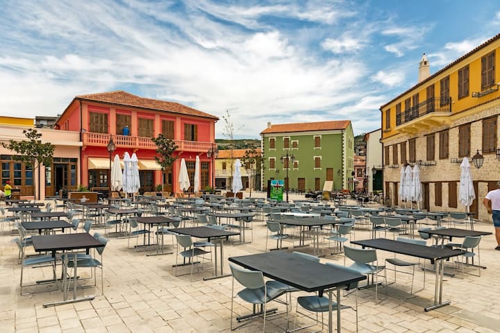
Old-town center is not that old, at least with European & Middle-Eastern Old in mind. Nice kilometer of shops though :)
Reeser Str. 106, 46446 Emmerich am Rhein, Německo
Old-town center is not that old, at least with European & Middle-Eastern Old in mind. Nice kilometer of shops though :)
Walkway overlooking the Adriatic Sea, with dining options, sunset views & night-time floodlights.
27 místní doporučují
Lungomare - Vlore
Walkway overlooking the Adriatic Sea, with dining options, sunset views & night-time floodlights.
This castle was built in the village with the same name which is about 6 kilometres (4 mi) from Vlorë. The castle rises on the side of the Shushica Mountain, about 380 metres (1,250 ft) above sea level. The castle was built on the site of an ancient settlement, one of the oldest in the Vlora region. The castle is believed to have been erected in the 3rd century B.C. In the 4th century B.C. the castle was transformed into a fortress town. In the 6th century A.D. the castle was reconstructed by Justinian I. The castle was the center of the Principality of Valona in the 14th century.
26 místní doporučují
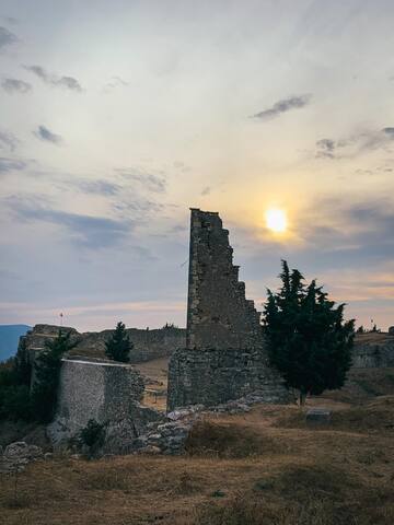
Kanine Castle
This castle was built in the village with the same name which is about 6 kilometres (4 mi) from Vlorë. The castle rises on the side of the Shushica Mountain, about 380 metres (1,250 ft) above sea level. The castle was built on the site of an ancient settlement, one of the oldest in the Vlora region. The castle is believed to have been erected in the 3rd century B.C. In the 4th century B.C. the castle was transformed into a fortress town. In the 6th century A.D. the castle was reconstructed by Justinian I. The castle was the center of the Principality of Valona in the 14th century.
The Llogara National Park is a national park centered on the Ceraunian Mountains along the Albanian Riviera in Southwestern Albania, spanning a surface area of 1,010 ha. The park's terrain includes large alpine meadows, vertical rock faces, precipices and dense forests.
66 místní doporučují
Llogara
SH8The Llogara National Park is a national park centered on the Ceraunian Mountains along the Albanian Riviera in Southwestern Albania, spanning a surface area of 1,010 ha. The park's terrain includes large alpine meadows, vertical rock faces, precipices and dense forests.
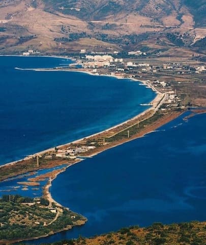
Orikum or Pashaliman is a town and a former municipality in Vlorë County, southwestern Albania. At the 2015 local government reform it became a subdivision of the municipality Vlorë. It was named after the ancient city Oricum, which was located 4 km west of modern Orikum. The population at the 2011 census was 5,503.
Orikum Beach
Orikum or Pashaliman is a town and a former municipality in Vlorë County, southwestern Albania. At the 2015 local government reform it became a subdivision of the municipality Vlorë. It was named after the ancient city Oricum, which was located 4 km west of modern Orikum. The population at the 2011 census was 5,503.
Vlora Baypass Panorama
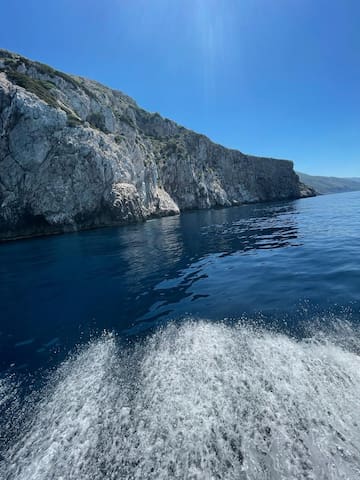
The Karaburun Peninsula is a peninsula of the Mediterranean Sea located in Southern and Southeastern Europe, which is almost completely surrounded by both the Adriatic Sea to the north and the Ionian Sea to the south
Karaburun, Albánie
The Karaburun Peninsula is a peninsula of the Mediterranean Sea located in Southern and Southeastern Europe, which is almost completely surrounded by both the Adriatic Sea to the north and the Ionian Sea to the south
Sazan is an Albanian uninhabited island in the Mediterranean Sea. The largest of Albania's islands, it is a designated military exclusion zone; it lies in a strategically important location between the Strait of Otranto and the mouth of the Bay of Vlorë, marking the border between the Adriatic and Ionian seas. The island has a surface area of 5.7 km2 (2.2 sq mi). It is 4.8 km (3.0 mi) long and 2 km (1.2 mi) wide, and its coastline measures about 15 km (9.3 mi).
In 2010, 2,721.87 hectares (6,725.9 acres) of the island's surrounding marine area was designated as the Karaburun-Sazan Marine Park. In clear weather, Sazan is sometimes visible from the coast of Salento, Italy, to its west. The island has been open to the public since July 2015
Sazan, Albánie
Sazan is an Albanian uninhabited island in the Mediterranean Sea. The largest of Albania's islands, it is a designated military exclusion zone; it lies in a strategically important location between the Strait of Otranto and the mouth of the Bay of Vlorë, marking the border between the Adriatic and Ionian seas. The island has a surface area of 5.7 km2 (2.2 sq mi). It is 4.8 km (3.0 mi) long and 2 km (1.2 mi) wide, and its coastline measures about 15 km (9.3 mi).
In 2010, 2,721.87 hectares (6,725.9 acres) of the island's surrounding marine area was designated as the Karaburun-Sazan Marine Park. In clear weather, Sazan is sometimes visible from the coast of Salento, Italy, to its west. The island has been open to the public since July 2015
Dalan Beach
Vuno is a village in Himara municipality, Vlorë County, Albania. It is located along the road between the municipal centre of Himarë and the village of Dhërmi in the Albanian Riviera
Vuno Village
Vuno is a village in Himara municipality, Vlorë County, Albania. It is located along the road between the municipal centre of Himarë and the village of Dhërmi in the Albanian Riviera
Dhërmi is a village in Vlorë County, Albania. It is part of the municipality of Himarë. The village lies 42 kilometers south of the city of Vlorë and about the same distance north of the southern city of Sarandë
Reeser Str. 106, 46446 Emmerich am Rhein, Německo
Dhërmi is a village in Vlorë County, Albania. It is part of the municipality of Himarë. The village lies 42 kilometers south of the city of Vlorë and about the same distance north of the southern city of Sarandë
Apollonia was an Ancient Greek trade colony which developed into an independent polis, and later a Roman city, in southern Illyria. It was located on the right bank of the Aoös/Vjosë river, approximately 10 km from the eastern coast of the Adriatic Sea.
6 místní doporučují
Archeologický park Apollonia
Apollonia was an Ancient Greek trade colony which developed into an independent polis, and later a Roman city, in southern Illyria. It was located on the right bank of the Aoös/Vjosë river, approximately 10 km from the eastern coast of the Adriatic Sea.
As the building which hosted the operations of the very first Albanian government, the Museum of Independence in Vlorë is strategically positioned in a location that testifies to its significance, near the port, with a beautiful view of the sea. This modest, two-story house is filled with the weight of history! Founded in 1936, this museum is considered to be the first one in Albania before the ’90s. This national museum offers the most comprehensive information regarding the most culminating events in the life of a country. It was in the famous balcony of this bright yellow, traditional house that Ismail Qemali raised the Albanian flag in 1912.
In 1912, at the peak of the crisis in the Balkans, this authentic house gathered delegates from the entire country to signal the new era. The small, impeccably organized space, decorated in 19th century style, is arranged into two main divisions linked by two corridors which join the two separate floors of the house with one another. Open every day of the week with the exception of Monday, the Museum welcomes all visitors in its space, sharing with the public original objects of the time, such as documents of the Renaissance and Independence periods in Albania. Starting from its front yard, the house is enriched with documents from the state archive, sparking curiosity about everyone involved in the great events that took place here.
Bronze busts of the ministers who formed the first government stand visibly in the front yard, along with the copy of the original carriage used by the Father of the Albanian independence, Ismail Qemali. Through its exhibition, the small house reveals the difficult conditions under which Albanian independence was established. Some of the most historically significant objects on display are personal objects belonging to the ministers, several furniture pieces from the office of the Prime Minister, Ismail Qemali, such as his chair and book shelves, the original flags used in battles leading to the declaration of independence, the actual declaration including all the participants’ signatures, iconic photographs which have captured and immortalized the crucial moment as well as paintings of the crucial people and events that left an indelible mark during such a tumultuous time.
27 místní doporučují
National Museum of Independence
SH8As the building which hosted the operations of the very first Albanian government, the Museum of Independence in Vlorë is strategically positioned in a location that testifies to its significance, near the port, with a beautiful view of the sea. This modest, two-story house is filled with the weight of history! Founded in 1936, this museum is considered to be the first one in Albania before the ’90s. This national museum offers the most comprehensive information regarding the most culminating events in the life of a country. It was in the famous balcony of this bright yellow, traditional house that Ismail Qemali raised the Albanian flag in 1912.
In 1912, at the peak of the crisis in the Balkans, this authentic house gathered delegates from the entire country to signal the new era. The small, impeccably organized space, decorated in 19th century style, is arranged into two main divisions linked by two corridors which join the two separate floors of the house with one another. Open every day of the week with the exception of Monday, the Museum welcomes all visitors in its space, sharing with the public original objects of the time, such as documents of the Renaissance and Independence periods in Albania. Starting from its front yard, the house is enriched with documents from the state archive, sparking curiosity about everyone involved in the great events that took place here.
Bronze busts of the ministers who formed the first government stand visibly in the front yard, along with the copy of the original carriage used by the Father of the Albanian independence, Ismail Qemali. Through its exhibition, the small house reveals the difficult conditions under which Albanian independence was established. Some of the most historically significant objects on display are personal objects belonging to the ministers, several furniture pieces from the office of the Prime Minister, Ismail Qemali, such as his chair and book shelves, the original flags used in battles leading to the declaration of independence, the actual declaration including all the participants’ signatures, iconic photographs which have captured and immortalized the crucial moment as well as paintings of the crucial people and events that left an indelible mark during such a tumultuous time.
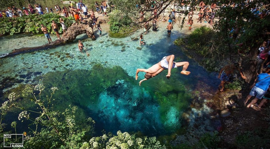
The "Blue Eye" (Albanian: Syri i Kaltër) is a water spring and natural phenomenon occurring near the village of Muzinë in Finiq municipality, southern Albania.[3] A popular tourist attraction, the clear blue water of the river can be seen from a depth of more than fifty metres. Divers have descended to fifty metres, but it is still unclear what the actual depth of the karst hole is.
Blue Eye, Albánie
The "Blue Eye" (Albanian: Syri i Kaltër) is a water spring and natural phenomenon occurring near the village of Muzinë in Finiq municipality, southern Albania.[3] A popular tourist attraction, the clear blue water of the river can be seen from a depth of more than fifty metres. Divers have descended to fifty metres, but it is still unclear what the actual depth of the karst hole is.
Marina Bay Luxury Resort and Spa
Rr. Aleksander MoisiuLuxury Resort
Vila Arial
Location Of Villa
Amantia
Archeological Area
Located only 90 Min from Villa Arial is a hidden gem and a must visit place. For tours with private car ask at any time
Ujëvara e Peshturës Progonat
Located only 90 Min from Villa Arial is a hidden gem and a must visit place. For tours with private car ask at any time
Located only 100 min drive from Villa these place should be in must visit list. Private tours are also organized by me
Nivica Canyon
Located only 100 min drive from Villa these place should be in must visit list. Private tours are also organized by me
Orikum Marina
Manastiri i Shën Mërisë
Beach Acces
Vajana Beach Restaurant, Albánie
Good Private Beach
Karafili Resort
Blue Paradise Beach
Bora Bora
SH8Radhimë Beach
SH8Zanzara Beach Bar
Dalan Beach
Plazhi i vjeter
Saint Tropez Vlore
Rr. SazaniBar
Bar Da Vinci
Rruga Murat TërbaçiGreat Music
Irish Time
Pub And Good Beers
Seasons Cocktail Bar
Good Cocktail Bar and Good Music
Galeria Art Cafe’
Doporučení související s městem
Nenech si ujít
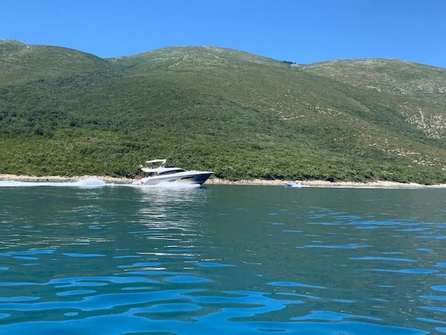
Private Tour With Boat To Karaburun Peninsula & Sazan Island
Are you ready for an unforgettable adventure in the stunning
Vlore region of Albania? Look no further than our travel tour agency
based in the heart of Vlore. We offer a wide range of exciting services, including boat trips that take you to the breathtaking Karaburun peninsula
and Sazan Island. You can also choose from our group tours or private
tours. Our experienced guides will ensure your safety and make sure you
have an enjoyable experience as you explore the natural beauty and rich
cultural heritage of this incredible region.
For more information and tickets you can ask me at anytime